Reporting live from Columbus…

(From L to R): Howson Staub, Sur, Bosso, and Pollack.
Let the shenanigans begin!

Reporting live from Columbus…
(From L to R): Howson Staub, Sur, Bosso, and Pollack.
Let the shenanigans begin!
This better not be your plan when the power goes out…

One of the main reasons why people evacuate from the safety of their home is because they have no power source. For 2015 National Preparedness Month, here’s a few tips you can use before the power goes out:
Because no one likes a dead cell phone or portable device right?
Don’t wait. Communicate. Make your emergency plan today.

Plug into knowledge…and get better prepared today.
Be powered and Ready by starting here!
When the power goes out, your flashlights should be ready to go.
Me? Here are just a few of the flashlights I carry with me every day.
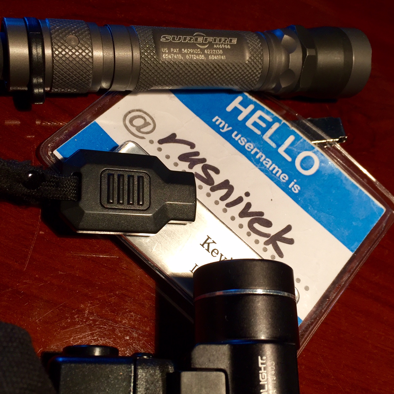
Yes, I actually carry 3 different flashlights all the time.
So if you’ve been to a preparedness class with me, you’ve seen my gear.
What kind of flashlights do you carry?
Don’t wait. Communicate. Make your emergency plan today.
Knowledge is power…so share your power safety tips with everyone.
Don’t get lost in the dark – Be Ready by starting here!
2015 National Preparedness Month – and yes, it’s still a week worth of good power safety tips!
Never use a generator, gasoline-powered equipment and tools, grill, camp stove, or charcoal burning device inside or in any partially enclosed area, including a basement or garage.

Easy right? Use OUTSIDE!
Big or small…

…don’t forget to get your generator serviced regularly.

Or else this could happen.

Be careful!
Don’t wait. Communicate. Make your emergency plan today.
Knowledge is power…so share your power safety tips with everyone.
Be Ready by starting here!
Even during a power outage, this still has to work!
So be a hero and change the batteries in your smoke detector twice a year.

When seconds count…Do it!
Don’t wait. Communicate. Make your emergency plan today.
Chirp chirp!
Be Ready and start here!
4th week of 2015 National Preparedness Month is all about Power outages.
So do you have the power?
OK, that’s one power…but before you stick the Matrix in your chest, maybe simply start by charging your phone.

Don’t wait. Communicate. Make your emergency plan today.
You’re at your best when the road gets rough…
Be Ready by starting here!
Not going to lie, I’m pretty excited about another DHS/FEMA adventure.

Whoa is right!

Entry on Duty (EOD) date: 09/20/15
More news shortly.
Since we are in September aka 2015 National Preparedness month, here’s a quick rundown of all checklists, go packs, preparedness kits, and other assorted items on preparedness. Those items marked with a (*) and bold are to me the most critical ones.
Checklists for Family Preparedness Kit: checklist_2014
Family Communications plan (kids to complete) FEMA_plan_child_508_071513
*Family Communications plan (Parents to complete) FEMA_plan_parent_508_071513
*How much water do I need to prep: https://whereisrusnivek.com/2014/09/16/one-gallon-of-water-per-day-per-person-48-bottles-natlprep-prepared2014/
Distilled down, here’s the most essential parts of my preparedness kit: https://whereisrusnivek.com/2014/09/15/important-parts-of-my-emergency-preparedness-kit-natlprep-prepared2014/
MREs? Here’s what they are: https://whereisrusnivek.com/2014/09/14/3-days-of-food-per-person-for-your-emergency-preparedness-kit-natlprep-prepared2014/
*My tech disaster kit: https://whereisrusnivek.com/2014/09/20/tech-kit-how-geeky-or-nerdy-is-yours-natlprep-prepared2014/
*Have a pet? Here’s what’s in my Pet Emergency Preparedness Kit: https://whereisrusnivek.com/2014/09/19/your-pet-needs-an-emergency-preparedness-kit-too-check-out-the-one-i-have-ready-to-go-prepared2014-natlprep-woof/
Everyone always asks, what is readily in all my disaster kits – DuckTape: https://whereisrusnivek.com/2014/09/18/this-emergency-preparedness-kit-multipurpose-item-literally-sticks-to-everything-prepared2014-natlprep-tbt/
Better IRL whistle for attention? Horn me: https://whereisrusnivek.com/2014/09/17/a-better-whistle-for-your-emergency-preparedness-kit-natlprep-prepared2014/
*Enable EAS Alerts to all your mobile devices (turn your GPS location on).
*On Twitter, follow @FEMA and your state’s Emergency Management Agency for good preparedness lists and more emergency response information.
On Facebook, follow your local National Weather Service Office for updates on current weather conditions.
Subscribe to your local Emergency Management’s informational pushes on their respective mass notification system.
*Print out a list of your immediate and extended family’s home and cell phone numbers (I nerd it out and happen to use the DHS/FEMA ICS-205 form).
*Keep your mobile devices and cell phones charged up.

Stay safe peeps!
Third Saturday in the 2015 National Preparedness Month! Last day/chance for hurricanes.
Do you want to have a better understanding of the hurricane risk you and your community face? Below is a map of the United States and the frequency of hurricane and tropical storm activity by county. Atlantic data dates back to 1851, while Pacific data includes storms since 1949.

Map Information: This area is a map of the continental United States, Puerto Rico, Alaska, and Hawaii including state boundaries. It is entitled “Frequency of Hurricane and Tropical Storm Activity by County: 1851-2012”. It includes data from NOAA NHC HURDAT2 database; all classified hurricanes and tropical storms which made landfall within the 50 states, the District of Columbia, or Puerto Rico; paths by county within a 125 mile band of the center point, based on longitude. Atlantic data from 1851-2012, Pacific data from 1949-2012.Map Description: The frequency of hurricane and tropical storms are represented by a four point scale. The first group with the highest frequency of hurricanes and tropical storms includes between 65-141 occurrences of a hurricane or tropical storm. The area of states for this level of the scale includes the coastal edges of Texas, Louisiana, Mississippi, Alabama, Georgia, South Carolina, North Carolina, Virginia, and Delaware, as well as all of Florida. The second group with the second highest frequency of hurricanes and tropical storms includes between 29-64 occurrences of a hurricane or tropical storm. The area of states for this level includes inland portions of states in the first group, as well as Maryland, New Jersey, New York, Connecticut, Rhodes Island, Massachusetts, New Hampshire and Maine, as well as all of Puerto Rico. The third group with the lowest frequency of hurricanes and tropical storms includes between 1-29 occurrences of a hurricane or tropical storm. This area of states covers a large portion of the United States, and extends from Vermont in the east to southern California in the west, and from central Texas in the south to all of Michigan in the north, as well as Hawaii. The last group in the scale represents no occurrences of a hurricane or tropical storm. This area of states covers all of Alaska, Washington state, Oregon, Idaho, Montana, Wyoming, Colorado, North Dakota, South Dakota, Minnesota, all of Utah excluding the southwestern tip, and parts of California, Nevada, New Mexico, Kansas, Nebraska, Iowa, and Wisconsin. In all about two-thirds of the US are within one of the first three frequency groups. Federal Emergency Management AgencyORR Mapping and Analysis Center, Washington, D.C., March 13, 2014. Sources: ESRI, USGS.
It’s only a matter of time before you are affected by a hurricane.
Don’t wait. Communicate. Make your emergency plan today.
#Hurrycaine Hurricanes are dangerousso get Ready by starting here
(#Hurrycaine <==get it?)
It’s full scale exercise time…who’s excited?
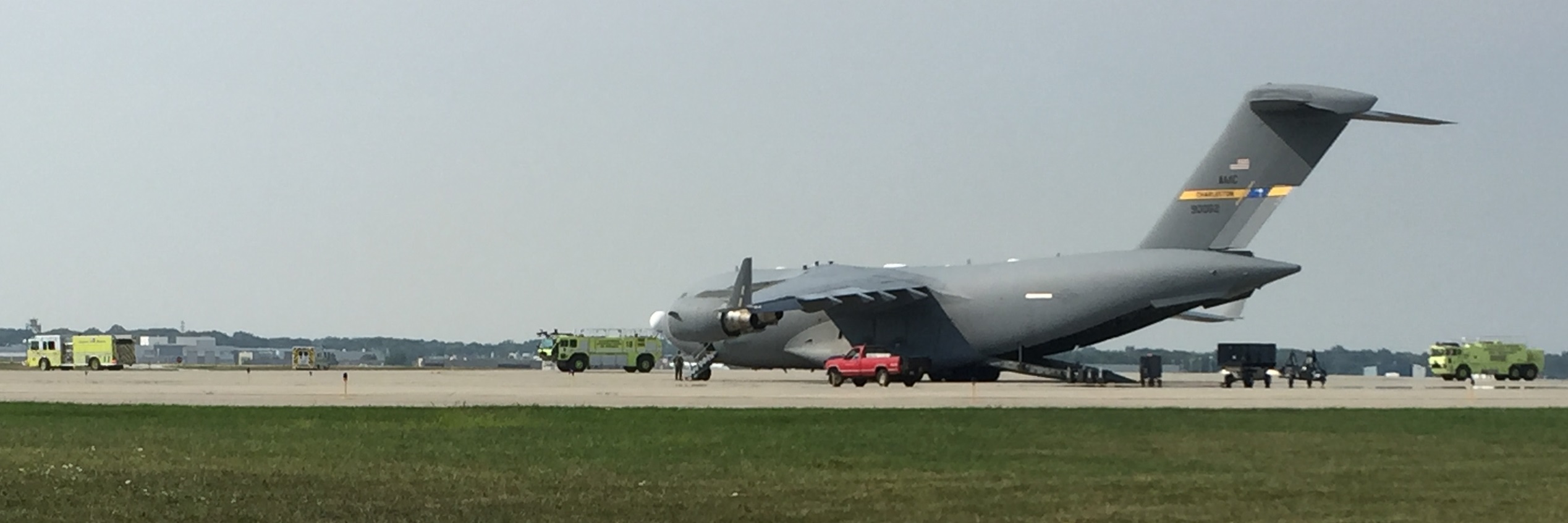
********This is only training – only a planned drill********
Wait, doesn’t everyone hang out at the airport on Saturdays?
