How frequent are hurricanes in the US? #NatlPrep #hurrycaine

Third Saturday in the 2015 National Preparedness Month! Last day/chance for hurricanes.

Do you want to have a better understanding of the hurricane risk you and your community face? Below is a map of the United States and the frequency of hurricane and tropical storm activity by county. Atlantic data dates back to 1851, while Pacific data includes storms since 1949.

hurricanemap750w

Map Information: This area is a map of the continental United States, Puerto Rico, Alaska, and Hawaii including state boundaries. It is entitled “Frequency of Hurricane and Tropical Storm Activity by County: 1851-2012”. It includes data from NOAA NHC HURDAT2 database; all classified hurricanes and tropical storms which made landfall within the 50 states, the District of Columbia, or Puerto Rico; paths by county within a 125 mile band of the center point, based on longitude. Atlantic data from 1851-2012, Pacific data from 1949-2012.Map Description: The frequency of hurricane and tropical storms are represented by a four point scale. The first group with the highest frequency of hurricanes and tropical storms includes between 65-141 occurrences of a hurricane or tropical storm. The area of states for this level of the scale includes the coastal edges of Texas, Louisiana, Mississippi, Alabama, Georgia, South Carolina, North Carolina, Virginia, and Delaware, as well as all of Florida. The second group with the second highest frequency of hurricanes and tropical storms includes between 29-64 occurrences of a hurricane or tropical storm. The area of states for this level includes inland portions of states in the first group, as well as Maryland, New Jersey, New York, Connecticut, Rhodes Island, Massachusetts, New Hampshire and Maine, as well as all of Puerto Rico. The third group with the lowest frequency of hurricanes and tropical storms includes between 1-29 occurrences of a hurricane or tropical storm. This area of states covers a large portion of the United States, and extends from Vermont in the east to southern California in the west, and from central Texas in the south to all of Michigan in the north, as well as Hawaii. The last group in the scale represents no occurrences of a hurricane or tropical storm. This area of states covers all of Alaska, Washington state, Oregon, Idaho, Montana, Wyoming, Colorado, North Dakota, South Dakota, Minnesota, all of Utah excluding the southwestern tip, and parts of California, Nevada, New Mexico, Kansas, Nebraska, Iowa, and Wisconsin. In all about two-thirds of the US are within one of the first three frequency groups. Federal Emergency Management AgencyORR Mapping and Analysis Center, Washington, D.C., March 13, 2014. Sources: ESRI, USGS.

It’s only a matter of time before you are affected by a hurricane.

Don’t wait. Communicate. Make your emergency plan today.

CKYhdyqUMAQdNj1

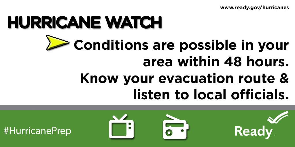
#Hurrycaine Hurricanes are dangerousso get Ready by starting here

(#Hurrycaine <==get it?)

@rusnivek

#TBT to the Category 4 Hurricane Kevin (1991) #NatlPrep #Saffir #Simpson #Wind #Scale

TBT to a Category 4 Hurricane Kevin from 1991.

HurricaneKevin-track-1991

Whoa-Hurricane Kevin was quite strong.

Saffir-Simpson Hurricane Wind Scale: The Saffir-Simpson Hurricane Wind Scale is a 1 to 5 rating based on a hurricane’s sustained wind speed. This scale estimates potential property damage. Hurricanes reaching Category 3 and higher are considered major hurricanes because of their potential for significant loss of life and damage. Category 1 and 2 storms are still dangerous, however, and require preventative measures. In the western North Pacific, the term “super typhoon” is used for tropical cyclones with sustained winds exceeding 150 mph.

Category Sustained Winds Types of Damage Due to Hurricane Winds
1 74-95 mph
64-82 kt
119-153 km/h
Very dangerous winds will produce some damage: Well-constructed frame homes could have damage to roof, shingles, vinyl siding and gutters. Large branches of trees will snap and shallowly rooted trees may be toppled. Extensive damage to power lines and poles likely will result in power outages that could last a few to several days.
2 96-110 mph
83-95 kt
154-177 km/h
Extremely dangerous winds will cause extensive damage: Well-constructed frame homes could sustain major roof and siding damage. Many shallowly rooted trees will be snapped or uprooted and block numerous roads. Near-total power loss is expected with outages that could last from several days to weeks.
3
(major)
111-129 mph
96-112 kt
178-208 km/h
Devastating damage will occur: Well-built framed homes may incur major damage or removal of roof decking and gable ends. Many trees will be snapped or uprooted, blocking numerous roads. Electricity and water will be unavailable for several days to weeks after the storm passes.
4
(major)
130-156 mph
113-136 kt
209-251 km/h
Catastrophic damage will occur: Well-built framed homes can sustain severe damage with loss of most of the roof structure and/or some exterior walls. Most trees will be snapped or uprooted and power poles downed. Fallen trees and power poles will isolate residential areas. Power outages will last weeks to possibly months. Most of the area will be uninhabitable for weeks or months.
5
(major)
157 mph or higher
137 kt or higher
252 km/h or higher
Catastrophic damage will occur: A high percentage of framed homes will be destroyed, with total roof failure and wall collapse. Fallen trees and power poles will isolate residential areas. Power outages will last for weeks to possibly months. Most of the area will be uninhabitable for weeks or months

Don’t wait. Communicate. Make your emergency plan today.

CKYhdyqUMAQdNj1

Hurricanes are unpredictable so get Ready by starting here for free!

@rusnivek

Hurricane: Watch vs Warning #NatlPrep #Hurricane

For hurricanes, do you know the difference between Watch vs Warning?

1559250_845215625565125_4829780281827812212_o

and

10478706_845214062231948_8337736483761113188_o

Simple huh?

For more information, check out FEMA’s Ready.Gov program.

And be prepared for the next hurricane!

Don’t wait. Communicate. Make your emergency plan today.

CKYhdyqUMAQdNj1

Awwww yeah, I’m talking about hurricanes on a Windsday.

@rusnivek

New technologies for NHC #NatlPrep #Hurricane

10 years ago, Hurricane Katrina ravaged the gulf states.

CGGFEEzWYAIMTWO

However, with the advances in technology, the National Hurricane Center has improved their prediction forecast…aka technology has improved to showcase the areas likely to be hit.

18421989-mmmain

Regardless of your location, please prepare for hurricanes.

Yes, three years ago, I was told “…that will never happen here” and “Stop wasting your time.” Soon after, Hurricane Sandy hit Ohio in 2012.

db772373ffb1c51d4816c8e7b17c8ae4

Know where to go. If you are ordered to evacuate, know the local hurricane evacuation route(s) to take and have a plan for where you can stay. Contact your local emergency management agency for more information.

No matter where you are, please prepare for hurricanes.

Don’t wait. Communicate. Make your emergency plan today.

CKYhdyqUMAQdNj1

No one wants to be unprepared.

@rusnivek

Double checking my weather radio for #NatlPrep #Hurricane

Peeking into the third week of National Preparedness Month – this week is all about Hurricanes!

So to make sure we are all prepared, I double checked my weather radio yesterday.

weatherradiocheck

I’m Ready!

If you live in Ohio, don’t forget to program your weather radio with these specific frequencies.

Don’t wait. Communicate. Make your emergency plan today.

CKYhdyqUMAQdNj1

Third week in. Are you Ready?

@rusnivek

Day-2 of the 2015 Kentucky Governor’s Emergency Management conference for the Disaster Recovery course

Second and final day of Disaster Recovery here at the Kentucky Governor’s Emergency Management Conference. As the lead instructor, it’s game time peeps!

I started the class out with some FEMA videos on the #Katrina10 recovery operation ongoing for Louisiana. They encompassed topics like whole community, public-private partnership, Faith-based organizations, and of course Fire/EMS public safety from SBPFD.


I then started laying the groundwork in the class for the end of day capstone recovery exercise.


But before lunch, I was requested to instruct in the adjacent room and teach the live video section of the KY Basic Public Information Officer (PIO) Course for Mike and Buddy. Addressing platforms and uses for situational awareness/common operating picture.


Nice to see some new PIOs in front of a camera. They did fairly well.

After lunch, we did some work with forms and cost recovery with Judge Bertram.


Overall, everyone had a great time learning and collaborating ideas for future Post Disaster Recovery plans. I’m looking forward to seeing Kentucky’s success in their enhanced recovery process now.

Special thanks to the Kentucky Emergency Management Office, KESC, and Ohio EMA for the invite and allowance to speak to all 38 Emergency Management Directors, 2 EM coordinators, 1 EM planner, 1 USAR, 1 lawyer, and 1 county executive. I’m also so glad to have the largest class at the conference too.

In anticipation for AlohaFridays, they broke out their best Aloha on a Thursday afternoon…Just. For. Me.

IMG_0620
My new peeps! Reporting live from Kentucky…

@rusnivek

2015 FEMA Individual and Community Preparedness Award Winners

2015 FEMA Individual and Community Preparedness Award Winners

FEMA has announced the winners of the 2015 Individual and Community Preparedness Awards, recognizing the outstanding efforts of individuals, programs, and organizations throughout the country working to prepare their communities for emergencies.  These awards highlight innovative practices and campaigns that have made outstanding contributions toward making communities safer, better prepared, and more resilient. This year, FEMA asked applicants to highlight accomplishments that took place between January 1, 2014 and April 10, 2015.

“Effective emergency management requires commitment, teamwork and engagement by the entire community before disasters occur,” said FEMA Administrator Craig Fugate. “I congratulate the individuals and organizations that embody these ideals. Through their hard work and dedication, they are making our nation stronger and safer.”

The 11 FEMA Individual and Community Preparedness Award recipients will be recognized on September 8, 2015 in Washington, D.C. During the recognition ceremony, recipients will share their experiences, success stories, and lessons learned with fellow emergency management leaders.

A complete list of the recipients and the honorable mentions for each category is available at: http://www.ready.gov/citizen-corps/citizen-corps-awards. Award recipients by category are as follows:

  • Outstanding Citizen Corps Council Award: Ready New York, NYC Citizen Corps, NYC Community Emergency Response Team (CERT)
  • Community Preparedness Heroes Award: Craig Wolfe and Northern Berkshire Regional Emergency Planning Committee Members
  • Awareness to Action Award: City of Henderson (Nevada) Get READY! Stay READY! Campaign
  • Technological Innovation Award: Central U.S. Earthquake Consortium, Geographic Information System/Information Technology Working Group
  • Outstanding Achievement in Youth Preparedness Award: Alabama Be Ready Camp
  • Fifth Annual Recipients of the John D. Solomon Whole Community Preparedness Award: Ready Montana Program and Spartanburg County Office of Emergency Management (South Carolina)
  • Outstanding Community Emergency Response Team Initiatives Award: Orange County, California Community Emergency Response Team Mutual Aid Program
  • Outstanding Citizen Corps Partner Program Award: New Orleans Medical Reserve Corps
  • Excellence in Volunteer Sustainability Award: City of Irvine Community Emergency Response Team (California)

Congratulations to all the award recipients and honorable mentions! You continue to make your communities and the Nation proud!

fema_logo3

Starting 2015 National Preparedness Month, here’s @CraigatFEMA on @ReadyGov @PrepareAthon for #NatlPrep

Starting 2015 National Preparedness Month, here’s FEMA Administrator Craig Fugate on Ready.Gov and PrepareAthon for #NatlPrep

CraigAtFEMA-PrepareAthon (http://www.fema.gov/media-library/assets/videos/105555)

17287985-mmmain

Don’t wait. Communicate: Make your emergency plan today.

CKYhdyqUMAQdNj1

@rusnivek

Packed September for 3 different regions with #NatlPrep

August was quite the month of new stuff, and in true form, September will be just as exciting.

I am sure know that September is my most favorite month right? September is National Preparedness month where I’ll be featuring a whole bunch of different preparedness plans and you can participate and better prepare you and your family for disasters or emergencies. All of it…totally free!

But for the rest of the month, here’s the plan:

First week: I’ll be presenting at the Nebraska Infrastructure Protection Conference on Social Media intelligence and disasters. On day-2 of the conference, I’ll be giving the my national keynote presentation: Task Force Deployment to St. Bernard Parish Louisiana – Lower 9th Ward. Region-7 boom!

Second week: I’ll be presenting at the State of Kentucky Governor’s Emergency Management Workshop rolling out the brand new G-270.4 Recovery from Disaster course. Two days of critical recovery classes in Region-4…with me!

Third week: I’ll be in Columbus doing some Mass Fatality TtT classes with Ohio EMA and then delivering another Social Media course to Franklin County EMA. Back in Region-5.

Fourth week: We have the Ohio Department of Public Safety’s PIO Symposium (Friday September 25th, 2015) in Columbus.

And the Fifth week: I just might have some time to do some paperwork. Sigh.

IMG_1909

This will be a tough first few weeks, but looking forward to the various regions.

And remember: Make your emergency plan today.

CKYhdyqUMAQdNj1

@rusnivek