Awwww, thank you for the kind words! From the pros at the National Weather Service Office in Louisville.

*blush*
Wx love from the Louisville crew definitely made my day.

Awwww, thank you for the kind words! From the pros at the National Weather Service Office in Louisville.
*blush*
Wx love from the Louisville crew definitely made my day.
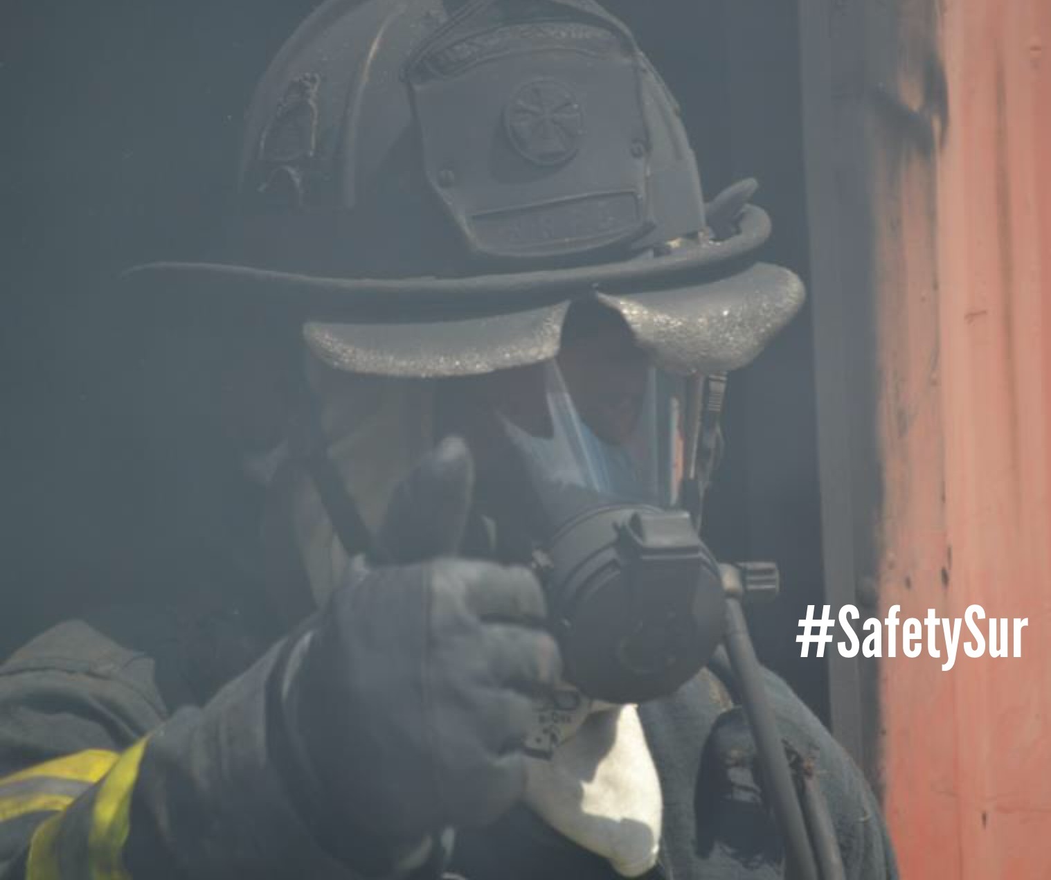
Ahhhhh, the last day of 2015 National Preparedness Month – THAT MEANS TODAY IS NATIONAL PREPAREDNESS DAY!!!!

Oh Yeah – You did it!
I know many of you have shared your tips and preparedness efforts with countless others. I am confident that your shared knowledge will pay off as we better prepare our fellow Americans for any disaster or emergency.
Thanks to all of our active partners in public safety. From the Locals to State to Federal partners who have made this month so successful – thank you!
Thank you to my agencies who have allowed me to share my preparedness tips with you.
I only wonder what will 2016 preparedness bring? Hmmm. Here’s a hint…
…and a little of this…

…and definitely more of this.

Who’s excited? <SQUIRREL!>
Don’t wait. Communicate. Make your emergency plan today.

Whew-I am so glad that many of you have decided to participate in this month’s activities. Keep in mind that you have 11 more months to address your public in finding ways to be better prepared in a disaster. Planning for the 2016 National Preparedness Month will begin shortly.
As always, start your peeps off right by sending them here.
Final week of 2015 National Preparedness Month!
Don’t freak out, still lots of things to do like download a bunch of free apps for your smart phone!
Here’s an example of a good app from the State of North Carolina Emergency Management Agency’s ReadyNC.

The ReadyNC app It talks about numerous preparedness activities as well as what to do after an emergency. Download it here.
FEMA’s got a great app that you can use to reference great info on disasters and preparedness.

Additionally you can check out their new Disaster Reporter feature, Social Hub, and get free vetted weather alerts. Download it here.
Easy way to inform others? Get out there and present/share your preparedness efforts with all your partners in public safety.

You know the phrase: An ounce of prevention/preparedness can save…..
Don’t wait. Communicate. Make your emergency plan today.
Download a bunch of free apps today!.
Get your Mundays over by clicking here!
Sunday! Sunday! Sunday! It’s the last week of 2015 National Preparedness Month!
I hope you showcase your new preparedness actions this Wednesday September 30th on 2015 National Preparedness Day!
This morning, I double checked my dog’s (Kacy – my PreparednessPup) emergency preparedness kit. As you can see, I have partitioned her food in individual ziplock packages to make it easier for portion control during feeding time.
And you guessed it, there are at least 3 days of food.

Having her own pet preparedness kit and making her carry it on her own if/when we have to evacuate will be a huge help.

Pet preparedness!!!!!

Master, I demand a rawhide for this NTED preparedness photo session.
For more information, check out the full details here.
Don’t wait. Communicate. Make your emergency plan today.
Don’t hesitate, be paw-sitively sure your pets are prepared.
Always be ready by clicking here!
When the power goes out, your flashlights should be ready to go.
Me? Here are just a few of the flashlights I carry with me every day.
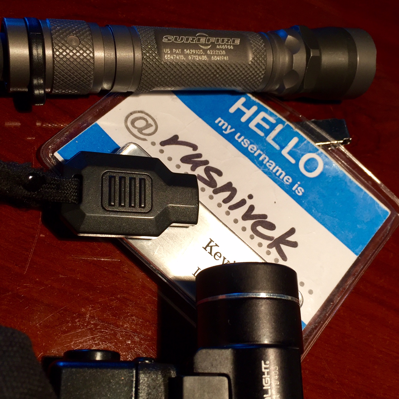
Yes, I actually carry 3 different flashlights all the time.
So if you’ve been to a preparedness class with me, you’ve seen my gear.
What kind of flashlights do you carry?
Don’t wait. Communicate. Make your emergency plan today.
Knowledge is power…so share your power safety tips with everyone.
Don’t get lost in the dark – Be Ready by starting here!
2015 National Preparedness Month – and yes, it’s still a week worth of good power safety tips!
Never use a generator, gasoline-powered equipment and tools, grill, camp stove, or charcoal burning device inside or in any partially enclosed area, including a basement or garage.

Easy right? Use OUTSIDE!
Big or small…

…don’t forget to get your generator serviced regularly.

Or else this could happen.

Be careful!
Don’t wait. Communicate. Make your emergency plan today.
Knowledge is power…so share your power safety tips with everyone.
Be Ready by starting here!
Third Saturday in the 2015 National Preparedness Month! Last day/chance for hurricanes.
Do you want to have a better understanding of the hurricane risk you and your community face? Below is a map of the United States and the frequency of hurricane and tropical storm activity by county. Atlantic data dates back to 1851, while Pacific data includes storms since 1949.

Map Information: This area is a map of the continental United States, Puerto Rico, Alaska, and Hawaii including state boundaries. It is entitled “Frequency of Hurricane and Tropical Storm Activity by County: 1851-2012”. It includes data from NOAA NHC HURDAT2 database; all classified hurricanes and tropical storms which made landfall within the 50 states, the District of Columbia, or Puerto Rico; paths by county within a 125 mile band of the center point, based on longitude. Atlantic data from 1851-2012, Pacific data from 1949-2012.Map Description: The frequency of hurricane and tropical storms are represented by a four point scale. The first group with the highest frequency of hurricanes and tropical storms includes between 65-141 occurrences of a hurricane or tropical storm. The area of states for this level of the scale includes the coastal edges of Texas, Louisiana, Mississippi, Alabama, Georgia, South Carolina, North Carolina, Virginia, and Delaware, as well as all of Florida. The second group with the second highest frequency of hurricanes and tropical storms includes between 29-64 occurrences of a hurricane or tropical storm. The area of states for this level includes inland portions of states in the first group, as well as Maryland, New Jersey, New York, Connecticut, Rhodes Island, Massachusetts, New Hampshire and Maine, as well as all of Puerto Rico. The third group with the lowest frequency of hurricanes and tropical storms includes between 1-29 occurrences of a hurricane or tropical storm. This area of states covers a large portion of the United States, and extends from Vermont in the east to southern California in the west, and from central Texas in the south to all of Michigan in the north, as well as Hawaii. The last group in the scale represents no occurrences of a hurricane or tropical storm. This area of states covers all of Alaska, Washington state, Oregon, Idaho, Montana, Wyoming, Colorado, North Dakota, South Dakota, Minnesota, all of Utah excluding the southwestern tip, and parts of California, Nevada, New Mexico, Kansas, Nebraska, Iowa, and Wisconsin. In all about two-thirds of the US are within one of the first three frequency groups. Federal Emergency Management AgencyORR Mapping and Analysis Center, Washington, D.C., March 13, 2014. Sources: ESRI, USGS.
It’s only a matter of time before you are affected by a hurricane.
Don’t wait. Communicate. Make your emergency plan today.
#Hurrycaine Hurricanes are dangerousso get Ready by starting here
(#Hurrycaine <==get it?)
10 years ago, Hurricane Katrina ravaged the gulf states.
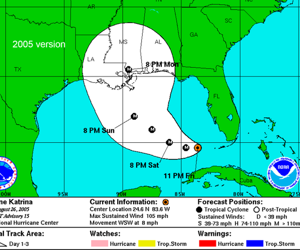
However, with the advances in technology, the National Hurricane Center has improved their prediction forecast…aka technology has improved to showcase the areas likely to be hit.

Regardless of your location, please prepare for hurricanes.
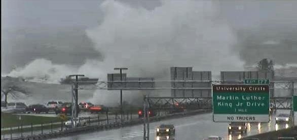
Yes, three years ago, I was told “…that will never happen here” and “Stop wasting your time.” Soon after, Hurricane Sandy hit Ohio in 2012.
Know where to go. If you are ordered to evacuate, know the local hurricane evacuation route(s) to take and have a plan for where you can stay. Contact your local emergency management agency for more information.
No matter where you are, please prepare for hurricanes.
Don’t wait. Communicate. Make your emergency plan today.
No one wants to be unprepared.
Peeking into the third week of National Preparedness Month – this week is all about Hurricanes!
So to make sure we are all prepared, I double checked my weather radio yesterday.
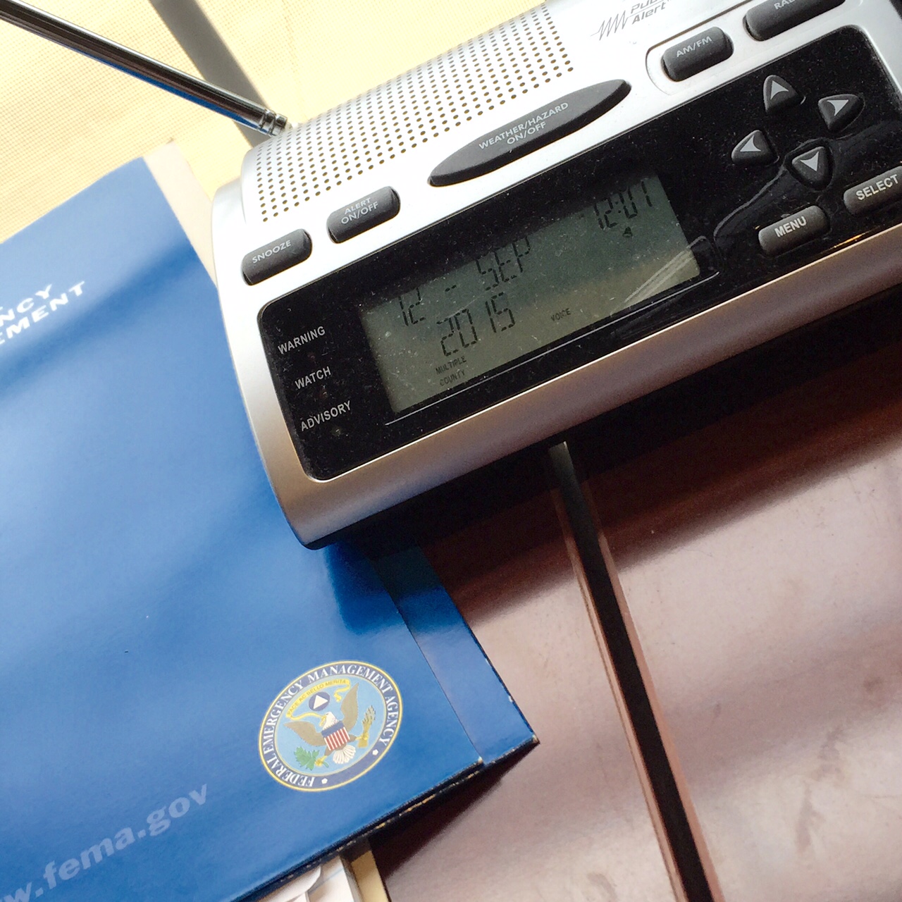
I’m Ready!
If you live in Ohio, don’t forget to program your weather radio with these specific frequencies.
Don’t wait. Communicate. Make your emergency plan today.
Third week in. Are you Ready?
Awwww yeah! This past week, I got a chance to teach part of the brand new DHS/FEMA G0290: Basic Public Information Officer Course!

Formerly known as G-290 course, this is the new FEMA Basic Public Information Officer course taught across the country for all public safety and emergency management professionals.
Thanks again to the Kentucky Emergency Management Agency and KESC for allowing me the opportunity. Also, special thanks to the ever fashionable Mike from NIOA.

Shakas because we are reporting live from Kentucky…
